A powerful late-winter storm system swept across large portions of the United States, bringing heavy snowfall, damaging winds and a heightened risk of tornadoes across multiple regions. From the Upper Midwest to the East Coast, severe weather conditions disrupted transportation, forced school closures and left hundreds of thousands of residents without electricity.
Meteorologists warned that the dynamic weather pattern would continue to move eastward, creating dangerous conditions across major population centers while delivering blizzard-like conditions in northern states. The same week also saw flooding rains affecting the Pacific region, highlighting the diverse and intense weather conditions affecting the country simultaneously.
According to the National Weather Service, the storm system developed along a strong cold front pushing through the central United States before advancing toward the Atlantic coast.
Updates on national weather forecasts and storm alerts are available at https://www.weather.gov.
Tornado and Damaging Wind Threat Across Eastern States
Forecasters warned that the most severe weather risks would concentrate along the mid-Atlantic region and parts of the southeastern United States. A fast-moving line of storms capable of producing damaging wind gusts and isolated tornadoes moved through major river valleys before tracking toward the Appalachian region.
Cities including Raleigh, Richmond and the nation’s capital, Washington, D.C., were placed under heightened severe weather alerts as the storm approached the East Coast.
Officials warned that wind gusts could exceed 70 miles per hour in some areas, creating risks for falling trees, power outages and hazardous driving conditions. Local authorities encouraged residents to activate emergency notifications on their mobile devices and stay informed about rapidly changing weather conditions.
The strong storm line moved across parts of the Mississippi, Tennessee and Ohio valleys before reaching the Appalachian Mountains, where forecasters expected thunderstorms capable of producing damaging straight-line winds and isolated tornado activity.
Weather monitoring platforms and aviation advisories tracking the storms can be accessed through https://www.accuweather.com.
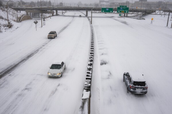
Heavy Snowfall Paralyzes Parts of the Upper Midwest
While the eastern states faced the threat of severe thunderstorms, the northern portion of the storm delivered heavy snow across parts of the Upper Midwest. Meteorologists predicted that some regions could receive more than 24 inches of snowfall, particularly across northern Wisconsin and the Upper Peninsula of Michigan.
Communities across these areas prepared for prolonged snowfall and strong winds that could create near-blizzard conditions and make travel extremely dangerous.
Air travel disruptions quickly spread throughout major transportation hubs in the region. Airports in Minneapolis, Detroit and Chicago reported hundreds of canceled flights as airlines attempted to manage hazardous conditions.
Operations at Minneapolis–Saint Paul International Airport experienced widespread cancellations as snow and high winds reduced visibility and complicated runway operations.
Flight delays and cancellations across the country were tracked through https://www.flightaware.com.
Major airports serving Chicago, including O’Hare and Midway, also reported significant delays and disruptions affecting travelers across domestic and international routes.
Flooding and Extreme Weather Continue in Hawaii
While much of the continental United States dealt with winter storms, the Hawaiian Islands experienced a separate but equally severe weather emergency. Torrential rainfall caused flash flooding, landslides and infrastructure damage across parts of the island of Maui.
Local officials reported that some areas received more than 20 inches of rainfall within a short period, flooding farmland, closing roads and forcing emergency response crews to conduct rescue operations.
Authorities temporarily issued evacuation warnings for certain communities while emergency crews monitored water levels in retention basins and drainage systems.
Flooding also caused damage to coastal roads and triggered mudslides in mountainous areas, complicating recovery efforts and limiting transportation access in several communities.
Local government updates and emergency information for residents can be accessed through the official county portal at https://www.mauicounty.gov.
As the severe weather system continued to move eastward, meteorologists warned that rapidly shifting conditions—from blizzard-like snowfall to severe thunderstorms—illustrate the complex dynamics of seasonal weather transitions across the United States. Experts noted that similar multi-region storms are not unusual during the late winter period, when cold northern air masses collide with warmer, moisture-rich systems moving north from the Gulf of Mexico.