Satellite images are offering an unprecedented look inside Iran as military operations intensify following coordinated strikes by the United States and Israel. High-resolution commercial imagery is now revealing the scale of destruction to Iranian military infrastructure, leadership compounds, and naval assets, providing analysts and governments with near real-time assessments of the unfolding conflict.
The aerial perspective underscores how modern satellite technology is reshaping war coverage, allowing independent verification of strategic targets and the broader operational impact across Iran’s territory.
Satellite Images Expose Damage in Tehran and Key Military Sites
The conflict opened with a daytime strike targeting Iranian leadership in central Tehran. Satellite imagery captured plumes of smoke rising from a heavily fortified compound associated with Supreme Leader Ayatollah Ali Khamenei, confirming structural destruction within the secured perimeter. The strike reportedly resulted in the death of the supreme leader, marking a historic and destabilizing moment for Iran’s political structure.
Beyond Tehran, commercial satellite providers have documented damage at multiple military installations. Images show destroyed hangars, cratered runways, and impacted storage facilities believed to house missile systems and drone units. Analysts reviewing imagery from various platforms, including publicly accessible databases, point to widespread structural compromise across strategic regions.
According to reporting and official briefings, the campaign expanded rapidly after the initial leadership strike. Facilities connected to Iran’s ballistic missile program and air defense network appear to have been among the targets. The visual evidence aligns with statements released by the <a href=”https://www.defense.gov” target=”_blank”>U.S. Department of Defense</a> outlining coordinated military objectives.
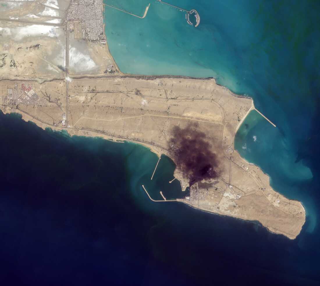
Naval Losses and Expanding Regional Operations
In addition to land-based targets, U.S. forces reportedly expanded operations toward Iran’s naval assets. Satellite images from ports along the Persian Gulf show visible damage to docked vessels and waterfront infrastructure. Burn marks and partially submerged hulls are consistent with naval strike operations.
President Donald Trump stated on his social media platform that he had been briefed on the sinking of nine Iranian naval vessels. While U.S. Central Command did not immediately confirm that specific figure, it acknowledged striking at least one Iranian warship in port. Updates from <a href=”https://www.centcom.mil” target=”_blank”>U.S. Central Command</a> have confirmed maritime engagement operations without disclosing full casualty or asset-loss numbers.
Imagery analysis suggests that damage to naval facilities could significantly affect Iran’s maritime mobility in the Strait of Hormuz, a critical global energy transit corridor. Disruption in this area may have economic implications extending beyond the region, particularly in oil markets where volatility often follows military escalation.
Regional Escalation and Strategic Implications
Reports circulating on social media platforms indicate that numerous Iranian military bases and compounds have been targeted nationwide. Satellite confirmations show repeated impacts across western, southern, and central Iran. In response, Iranian forces have reportedly launched retaliatory strikes across parts of the Middle East, raising concerns about a broader regional conflict.
Security experts note that satellite intelligence is now central to monitoring escalation patterns. Institutions such as the <a href=”https://www.cia.gov” target=”_blank”>Central Intelligence Agency</a> and the <a href=”https://www.state.gov” target=”_blank”>U.S. Department of State</a> rely on layered intelligence sources, including commercial imagery, to assess operational shifts and diplomatic risk.
The evolving situation highlights the strategic value of commercial satellite technology in modern warfare. Unlike previous conflicts, where information gaps persisted for days or weeks, high-resolution imagery now provides rapid confirmation of structural damage, troop movements, and infrastructure disruption. This transparency alters diplomatic calculations and international response timelines.
As military operations continue, satellite images are expected to play a crucial role in documenting additional strikes, naval engagements, and potential retaliatory actions. The scale of destruction already visible across Iranian military facilities signals a significant shift in regional power dynamics, with long-term implications for Middle East security, energy markets, and global geopolitical stability.
The situation remains fluid, and further satellite assessments are likely to provide deeper insight into the operational and strategic consequences of the ongoing campaign.