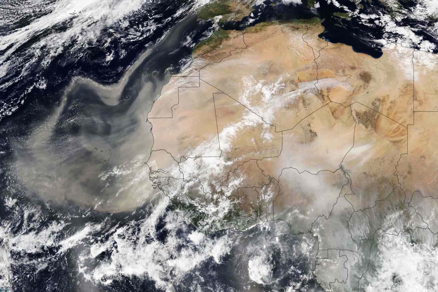
A dense Saharan dust Caribbean plume has turned skies hazy across thousands of miles of ocean and land as it drifts westward toward the United States. The large dust cloud, originating from the Sahara Desert, began affecting Caribbean islands earlier this week in what is now considered the region’s most significant dust event of 2025.
Stretching over 2,000 miles (3,200 kilometers) from Jamaica to beyond Barbados and about 750 miles (1,200 kilometers) from the Turks and Caicos Islands down to Trinidad and Tobago, the dust layer is visible on satellite images and clearly noticeable on the ground.
Health and Environmental Impact of the Dust
This atmospheric event has caused widespread sneezing, coughing, and eye irritation in affected areas. Meteorologists and health officials urge people with asthma, allergies, and respiratory issues to stay indoors or wear masks when outside. The dust has led to the year’s highest recorded aerosol optical depth—0.55—indicating a significant reduction in direct sunlight reaching the ground.
According to the National Oceanic and Atmospheric Administration (NOAA), aerosol optical depth measures how much sunlight is blocked by airborne particles, a critical factor in determining air quality and visibility.
Dust Plume Forecast for the United States
Forecast models predict the plume will reach Florida, Louisiana, Alabama, and Mississippi by late this week and into the weekend. Though the concentration typically weakens as the dust moves west, experts note that the eastern Caribbean often experiences the most intense effects, with heavy haziness capable of dimming the sun.
The Role of the Saharan Air Layer in Hurricane Season
The dry, dusty air mass known as the Saharan Air Layer travels from Africa across the Atlantic between April and October. Not only does it reduce air quality, but it also plays a role in hurricane activity by suppressing the development of tropical waves. This phenomenon is most active in June and July, when dust transport is strongest, with plumes traveling at altitudes between 1,500 and 6,000 meters.
In June 2020, a massive “Godzilla dust cloud” blanketed the Caribbean in the largest such event in 50 years. While this current plume is less extreme, it serves as a reminder of how far-reaching and powerful Saharan dust can be.